There are two choices for the south trailhead: One is located where the AT crosses a road that turns to the right a hundred yards before the AT bridge; I felt more secure parking at the AT lot that is (second and preferable choice) located on the left between Big Island and Glasgow where the steel AT bridge crosses the James River. There is ample parking here and several vehicles were parked overnight adding to a sense of security. North trailhead is located at a pull-over at MP 51.7 on the BRP. You must advise the BRP Office on the day of your trip, not before, that you will leave a vehicle in the pull-over, plate number, etc.
The trailhead areas are best reached, from Gso, by taking 29 North to Lynchburg; 501 to the BRP crossing; BRP to VA 130. Truck traffic on 501 , particularly after the BRP crossing, is horrendous. This use of the BRP will avoid two mountain crossings at 5 mph.
This is the AT. Well marked with signs and wear.
This is definitely a north to south hike. I can provide specific elevations if you do not have the elevation profiles.
Beginning on the BRP at the north end, climb 500-600 ft in half a mile to the turn-off for Punch Bowl Shelter. .2 miles to the shelter. Shelter sits in a hollow. Large shelter with pit toilet. Typical worn, muddy condition of most AT shelters from over-use. Small pond to the left as you approach the shelter. Across the pond is a nice meadow of a couple of acres with plenty of tent space where we set camp. Water source is below the pond/shelter. Negatives of the shelter: From the BRP it is a hard climb to the shelter. Unfortunately, there is a FS road a third of a mile from the shelter with a gentle incline from the FS road to the shelter. This ease of access means lots of use. We had two young men hike in late Friday and hang hammocks beyond our campsite, no problem. We had a couple arrive in the late afternoon, after several trips to trundle firewood in on a trolley cart in a cooler, carry a guitar and food accompanied by a Boxer - who made himself at home in our kitchen as we were eating dinner. I finally had to yell and throw something at the dog before they called him away. They set up at the shelter across the pond. A second couple arrived a short time later, they brought the bongo drums and two Beagles. None of the dogs, of course, were on a leash. The Beagles, excitable dogs in any event, were all over our cooking space. One of the Beagles came back later and, surprise, ended up in my lap with its nose in my (only) cup of cappuccino. The owner's only apology/excuse is that, "He is young and just learning"! The second couple also went to the shelter. Guitar and bongos could be heard late into the night.
Saturday morning, under full pack since this was a shuttle hike, another 600 to 700 ft to the top of Punch Bowl Mountain. Several ups and downs topping out at Brush Mountain (3,300 ft). Saturday afternoon a brutal descent of more than 2,000 ft on constant steps or switchbacks over very rough trail to John's Hollow.
John's Hollow also suffers from being only 1.5 miles from the trailhead on the James River. Again, a large shelter and pit toilet, water from an adjacent stream -- but worn and muddy. We arrived around 4 pm. Six to ten college kids in the shelter, though they were very well behaved. Another eight to ten men tented on the back side of the shelter for the night prepatory to a week's hike north on the AT. Very pleasant. Turned in early. Negatives of the shelter: Over-crowded. We were pressed for tent space.
In between the two over-used, over-crowded shelters is a beautiful hike of 9.0 miles. At lest 80% on the ridgeline with views to the east, west or both. James River Basin to the west. In addition to being a north to south hike, it is also an after/before leaf season hike. In the summer one would know nothing but of a walk in the woods.
Jerry Weston
Greensboro, NC
Wednesday, March 11, 2009

Monday, March 9, 2009
Adieu to our Outings Chair

Hi folks -
We in the Chapter are wishing our Outings Chair Chris Plummer a fond farewell. He's off to Utah, so he'll still have plenty of trails and mountains and arches to tame.
So, without Chris's steady hand behind the wheel of the Outings Blog, there will be a paucity of postings here until the Chapter elects a replacement. I will, however, post pictures of our fair state from time to time.
Best,
Mike in the Chapter Office
Friday, December 19, 2008
Hiking with Kids

Josh Thomas, our one and own Central Piedmont Group Chair, has a new post over at Ecochildsplay.com. So go over there and check out his seven tips; for now, here's a small preview:
1. Give kids real responsibility
Captain (hiking leader), Cook (snacks holder), Chief Navigator (map holder/user), Lead Photographer, etc. These all work. Just be sure you have a
role for each child.
2. Switch roles frequently
If you have 4 kids or fewer on the trip, switch often enough (roughly every 7-8
minutes for four kids) so that all can be Captain at least once per half hour.
3. Think Journey, Journey, Journey
Every time you announce a role change, remind yourself that this is about the journey, not the destination, and that the kids are dictating the pace (30 photos of tree sap? Of course that’s a good idea!)
Monday, November 24, 2008
Beginner Backpacker Class
We had our first class session this weekend in Raleigh and we covered a lot of territory. We discussed why anyone would want to backpack, both the practical and the metaphysical aspects, and we delved into gear and books and what folks expected from the class.
For a reference book we're using "The Backpacker's Field Manual" by Rick Curtis, who is director of the Princet on University Outdoor Action program. This is a good book because it covers every aspect of backpacking, so it is broad in nature.
For a reference book we're using "The Backpacker's Field Manual" by Rick Curtis, who is director of the Princet on University Outdoor Action program. This is a good book because it covers every aspect of backpacking, so it is broad in nature.
Saturday, November 22, 2008
Not All Layers are Created Equal!
I went on a two-hour day hike yesterday, and it was challenging with the wind blowing and the sun behind the clouds. It got me thinking just how important it is to layer clothing to stay warm, and reminded me that even in cold weather you still need to be able to ventilate, or shed layers, especially if you are carrying a pack.
I started out trying a layering system for winter weather, which seemed like a good idea given the wind chill in the low 30's. I quickly got hot & cold at the same time, too many layers on top and not enough below. I went back to my house and tried the layering system that I use for cold weather backpacking. My second try at layering was a noticeable improvement for hiking with a pack, and the other one will be OK for in camp where activity is low, and where you need more insulation.
So this reminded me that now all layers are created equal, and that trying things out certainly has its advantages.
Also, I'm lucky to live near an open space in the county [can hike there when the hunters aren't out] and I really like to hike in cold weather.
I started out trying a layering system for winter weather, which seemed like a good idea given the wind chill in the low 30's. I quickly got hot & cold at the same time, too many layers on top and not enough below. I went back to my house and tried the layering system that I use for cold weather backpacking. My second try at layering was a noticeable improvement for hiking with a pack, and the other one will be OK for in camp where activity is low, and where you need more insulation.
So this reminded me that now all layers are created equal, and that trying things out certainly has its advantages.
Also, I'm lucky to live near an open space in the county [can hike there when the hunters aren't out] and I really like to hike in cold weather.
Wednesday, October 22, 2008
Mt Rogers write up
Wilson Creek, Mt Rogers
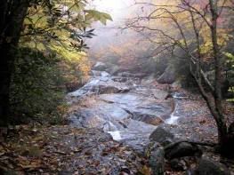
On Oct 10-12, 2008 the NC Chapter ran an educational basecamp outing instructing in the art of backcounty navigation. Our focus was learning basic map & compass skills in outdoor classes held over the weekend. We honed our new skills during a day-hike on Saturday and a workshop Sunday morning. Our Saturday hike wound it's way through the Wilson Creek basin, crossing Quebec Branch, and ascending Wilburn Ridge for some focused map and compass work, plotting bearings to the Scales and to 1st Peak. Afterward a large part of the group scaled the highest rock outcropping for a 360 degree view of the area, and stayed up there until completely oriented to the area, or perhaps because the view with clear skies was astounding.
We had lunch near the North end of Wilburn Ridge and afterwards shared a didactic talk about navigating using input from nature, say how to estimate your latitude from the position of the North Star above the horizon.
The outing was well attended with 13 participants, including some old hands, several new Sierra Club members, and Maria Bowling, Outings Chair for the New River Group in Virginia. Mt. Rogers proved to be a perfect location, with cooperation from all the folks at Greyson Highlands Park, and cooperation from the mother nature as well.
This area offers challenging terrain, with hiking trails and horse trails intersecting or sharing territory, and ridges folding into each other: "is that Wilburn Ridge, Pine Mountain, or 3rd Peak?". As we saw around Wilson Creek, it also contains the "Bermuda Triangle of the AT", where North is South, and South runs North!
Monday, October 13, 2008
MT Rogers Navigation Trip
I'm just back from MT Rogers, were we had a great 3 day class learning and practicing map and compass skills in the backcountry. The fall leaves were spectacular, we enjoyed two days of hiking along Wilson Creek, Quebec Branch, and Wilburn Ridge, and our campfire discussions were fascinating.
During this outing we covered a wide range of topics in class around the campfire. I'll update our Backpacker Book list to reflect the books and movies we discussed.
Thanks to all who participated! Feel free to comment on the trip here. I'll also be interested in your thoughts on other outings that you would like us to run.
I'll look forward to seeing you on the trail soon.
During this outing we covered a wide range of topics in class around the campfire. I'll update our Backpacker Book list to reflect the books and movies we discussed.
Thanks to all who participated! Feel free to comment on the trip here. I'll also be interested in your thoughts on other outings that you would like us to run.
I'll look forward to seeing you on the trail soon.
Subscribe to:
Posts (Atom)
